SW Trails Has Been Getting Things Done
Either by direct volunteer action or by working with the Portland city government SWTrails PDX works to move trails’ projects forward. Click on any of the points in the map below for details on the various projects completed by our volunteers.
Our ongoing work includes conducting volunteer-led monthly walks around SW Portland, hosting work parties to build and repair trails in the SWTrails network, and working with city government to advocate for safer trails, crossings, road shoulders and sidewalks throughout SW Portland.
SW Trails has had an impact on the neighborhood. For example, one family chose a house because of SW Trails.
Landowners Released from Liability
In the past, owners of land adjacent to rights-of-way in Portland had objected to establishing trails on the rights-of-ways, fearing that they would be liable for maintaining these trails and for any injuries incurred on the trails. SW Trails lobbied the Oregon Legislature and eventually saw the liability law changed, protecting not only homeowners but also nonprofit volunteer orgnizations like SWTrails PDX who build the trails. Learn more of the process HERE.
Recent Projects
Woods Creek Park (Spring, 2019)
An out-of-control vehicle destroyed what neighbors refer to as “Little Bridge” at the entrance to Woods Park. This important short trail connection is widely used by residents of Ashcreek and Crestwood neighborhoods. As a result, Friends of Woods park funded and helped build a replacement bridge with assistance from SWTrails PDX and the Ashcreek and Crestwood NET teams.

Lots of hard work went into replacing Little Bridge. 20 days after its destruction, April 22nd saw the replacement bridge in place, slightly larger, much stronger, and further from the road. A big thanks to all those who participated in restoring this path and safe off road access to Woods Park.
The new Little Bridge at Woods Creek Park (April, 2019)Bridlemile Walkway (Fall, 2018)
Bridlemile Walkway on SWTrails #1 (2018)
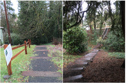
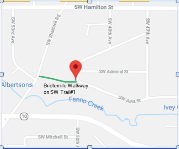 The portion of SWTrails #1 connecting SW Julia Ct to Shattuck Rd had detriorated over the 50 years since its construction into a muddy, rutted, weed-choked bumpy, pot-holed path. Bridlemile neighbors and SWTrails PDX volunteers turned the walkway into a clean, raised, smooth, hard surface built in compliance with Portland Parks & Recreation Trail Design Guidelines” (SW News). The project took 22 volunteers under the guidance of veteran SW Trails builders four weeks to create the wood ramps and raised turnpike that will make walking for everyone, including those with altered mobility and mobility devices, much easier. This part of Trail #1 connects residential areas with a commercial area, a school and a park. The project was funded by PBOT’s Portland in the Streets Community Grant program and was sponsored by SW Neighborhoods and the Bridlemile Neighborhood Association.
Seymour Court (Fall, 2018)
 47 new box steps set in gravel negotiate a 40-foot rise to complete the new Seymour Court Trail. This relatively short but very important 130-foot-trail connects the Willamette Greenway Trail and the South Portland neighborhood to Barbur and Terwilliger Boulevards and the Homestead and Hillsdale neighborhoods via the Corbett Street Bridge over I-5. This new set of steps and trail replace a steep and muddy informal pathway leading to the southeast end of the Corbett bridge to the sidewalk there. It’s a spiffy new route between Macadam and Barbur in an area in need of more pedestrian connections across I-5, and was conceived by the residents of SW Seymour Court, who also helped with design and implementation of the trail in conjunction with lots of technical and construction assistance of SWTrails PDX volunteers.
Funding for the project came from a grant from SW Neighborhoods Inc (SWNI), and is a partnership between the South Portland Neighborhood Association and SWTrails PDX.
Re-graveling Capitol Highway (October 2017)
SWTrails volunteers and neighbors distributed nearly 12 cubic yards of gravel, pulled weeds and widened the trail along the east side of Capitol Highway, between Taylors Ferry Road and Garden Home Road, making a wider, safer walkway to replace the muddy and narrow path. The gravel came from the Portland Bureau of Transportation’s Fixing Our Streets program. SWTrails and neighbors provided shovels, wheelbarrows and hard work.
Larger Projects Which Often Took Years of Effort
Marked trail routes throughout southwest Portland

Bertha Steps (2018)
 These 90 steps traverse a steep ravine to connect the lighted crossing at Beaverton Hillsdale Highway/SW 25th (the street leading up to Robert Gray Middle School) and SW Bertha St. After years of lobbying, fundraising, preparation and 325 hours of volunteer work by SWTrails advocate Don Baack, volunteers for SWTrails, neighbors and trail users finished the Bertha steps in February of 2018 (final cost: $22,000). The Bertha Trail connects with the SW 25th Trail, a project SWTrails is also sponsoring, and was funded by and designated as one of Portland’s Safe Routes to School. It provides a direct and safe way for children attending Robert Gray to walk safely to and from school from neighborhoods south of Beaverton Hillsdale Highway, including the Stephens Creek Crossing housing complex. Before the steps were built people could walk up and down the ravine, but the right-of-way was very steep in parts, and the entire trail became a muddy slip-‘n-slide during the rainy/winter season. These beautifully-built new steps also provide congregants at the Neveh Shalom synagogue, the Portland Christian Center and the Japanese Fellowship Church a safe walk to these buildings more easily. The steps are frequently used by neighbors walking to the Hillsdale Park off-leash area and is a popular destination for individuals or groups taking an urban hike through the area.
Steps Looking North
Steps Looking South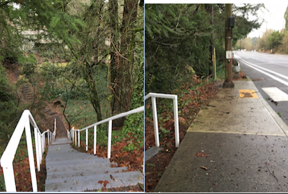
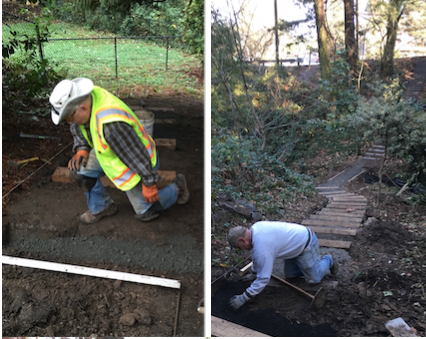 The work
4-T Trail

Click on the link above to further explore a most spectacular journey through southwest Portland on the 4 T’s: Trail, Tram, Trolley and Train.
Raz-Baack crossing


A path, stairs, and boardwalk going through the Stephens Creek natural area.
————————————————————————————-
SWTrails PDX Over the Years
The following is a partial list of projects that have been accomplished by SWTrails PDX, a 501 (c) 3 nonprofit organization since 2013:
- Developed the neighborhood walkway map in 1998 with input from all 17 southwest neighborhoods, including SWHRL which was not a part of SWNI at the time. This map showed where people want to walk in each neighborhood.
- Successfully prevented the vacation (give up the public’s right to use a right-of-way for transportation) of a number of unbuilt rights-of-way so they could be used as current or future trails.
- Developed the SW Urban Trails Plan mapping about 40 miles of linear trails in southwest Portland connecting key activity areas such as town centers and main streets with schools, parks, and viewpoints along walkable streets.
- Worked with PBOT to design the signs marking the 7 urban trails in southwest Portland.
- Did the field engineering for the location of the signs along 6 of the 7 SWTrails PDX routes (Trail 2, the Red Electric Trail, is still in the process of being developed).
- Organized and led 30 to 40 major projects to develop key connections along the SWTrails routes and on other important pedestrian connections on unbuilt rights of way and within parks. An estimated 200 to 300 volunteers have been involved in these efforts across SW Portland. Among the larger projects were
- The Raz Baack Crossing of Stephens Creek,
- The 70 plus stairs under the Terwilliger northbound on ramp to I-5,
- Trails in Woods, Dickinson and Marquam Parks,
- The Buhler Cutoff from Barbur to Terwilliger and many other key connections.
- Built more than 600 steps and over 2 miles of trails in the course of doing the above projects.
- Led the effort to develop the southwest Portland part of the 2030 Bicycle Master Plan which was adopted by City Council in 2009.
- Led the effort to develop the Southwest Portland Walking map and contracted with PBOT to provide valuable local knowledge of the thousands of connections and cut-throughs that exist in southwest Portland. The first walking map was published in 2003; 5 revisions have occurred since the original map was published.
- Organized and led monthly hikes throughout southwest Portland beginning in 2000 and continue today. Many hundreds of people have taken advantage of these hikes to see parts of southwest Portland they might otherwise never see.
- Lobbied for safe crossing of many streets, most recently to secure the soon-to-be installed crosswalk improvements at 4900 SW Barbur.
- Supported the effort led by Don Baack and Bruce Murray to develop, sign and improve the 4T trail.
- Brought focus on the poor infrastructure on Barbur, most recently focusing attention on the need to improve several Barbur Bridges, especially the Newbury and Vermont structures which are very narrow and do not have bicycle paths on them.
- Lobbied to obtain city/state funding for the Red Electric Pedestrian Bridge in Hillsdale currently under construction.
- Developed the SWNI Policy for Safe Routes to school; lobbied for standard and non standard street and trail improvements to make it safer for children to walk and bicycle to school. In some cases, constructed trail connections to make it safer for children to walk to school.
- Lobbied with the city of Portland and Metro to raise awareness of the transportation needs of southwest Portland where approximately 46% of our arterials and 85% of our local streets do not have sidewalks.
- Worked with several city bureaus to address vegetation management issues along our streets, sidewalks and trails.
- Worked with city government to put extended shoulders on Maplewood Road and Capitol Hill Road.